Click on photo to enlarge and scroll through


|
|
|
Click on photo to enlarge and scroll through
1 Comment
Sunday Mercantour – Day 3 Our final day of cycling in the Alps. We have been to the Vercors, the Northern Alps, the Southern Alps and the Alps Maritime. And today it is another sunny day in the French Alps and the final part of our Mercantour excursion. No lazy day to wind down though, we are going out in style (perhaps not much style, but a lot of push) with a final full-on big climb: TdF HC, the Col de la Cayolle tops out at 2,326m. Many of the mountain ingredients we have come to love and respect, including: Wide valleys, narrow sections of gorge, long balconies clinging to the hillside often with no protection between the road edge and oblivion and a sprinkling of tunnels. And in one place a Bailey Bridge over a chasm above the original collapsing bridge below. Needless to say plenty of hairpin bends. Road condition varying from good, to gravillon and/or bumpy. On one particularly bumpy section while descending at speed Sheila completely took off. Luckily she had the presence of mind to hang on with both hands and as we were going in a straight line at the time John could see her come back into view in the trike mirrors as she was caught again on her way down, with the seat bungee cord absorbing the impact. Also the usual bits of chausée deformé, from minor dips to bits of the roadside disappearing down the mountainside. The terrain progressed from high pasture with tinkling streams, to rocky heights and cliffs with long cascading waterfalls. A geologist’s paradise from moraine, through disintegrating and land slipping shale, to wildly folded sedimentary rock and hard rock cliffs. Possibly our best wildflower day ever – maybe because we were climbing the southern flank of the mountain. The lower pastures were awash with all colours and there was an endless mixture of flora in bloom along the roadside up to 1,900m. All colours of orchids and on the highest part the best banks of large gentians we have seen. A few marmot calls but the head (full body crossing road just below summit) count for the day was one only. The beginning of the climb was a fairly benign 4% to 5% (note how our steepness assessment has changed over two weeks!) but we knew we were in for several hours of unrelieved climbing and looking up at the mountains towering in front of us still had no exact idea where the road would go, so we stayed in the middle ring for a bit but took it at a steady pace. Good idea because lower gears and increased “grippyness” were soon the order of the day. Plenty of 8% climbing. About a third of the way up a small hamlet offered a restaurant / bar and Sheila suggested it was time to stop for ‘elevenses’. John put up a rather half-hearted suggestion of continuing on, but agreed within half a dozen further turns of the cranks. Cold drinks at a proper table and chairs. Needless to say later on we also made quite a few more roadside drinking and eating stops. Things got increasingly tough. Not sure about getting stronger as the holiday went on. John decided that he had peaked about 2 days earlier. This was no help when Sheila looked at the altitude on a km marker board and calculated we had 5km to go and 500m more to climb. A 10% average – but we know the misleading nature of averages and sure enough for every slight easing there was a 15% or more payback just around the next corner. Summit at last. Time for photos, a bit of self-congratulation, eating and drinking, and swapping a sweat drenched shirt for dry warm clothes and windproofs ready for the down. And a short time to enjoy the look on the faces of other cyclists and motorcyclists who could not really believe that two old pensioner farts like us had just cycled such a contraption as a recumbent tandem trike to the top of the Col de la Cayolle. Down and down and down, with the full panorama laid out, as well as the scary drops and corners not to be misjudged – And hooray nearly at the bottom a cafe right on the roadside on the apex of a hairpin bend. Cold drinks, omelettes and salad for a very late lunch. Back in Barcelonnette and the Trike is all packed up in the car ready for our two-day drive back to Lymington. Holiday verdict: EPIC Total number of named Cols climbed: 16 Total number of summit finishes: 2 Total number of highest roads in Europe: 1 Total number of marmots spotted: 35 Total number of p***tures: 0 Total metres climbed and litres of water drunk on the way: No idea, we lost count many days ago. (PS. We have heard that there are pensioner holiday coach tours available?) 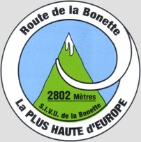 Saturday
Mercantour – Day 2 A typical cycle touring day in France. Today we swapped mountains for a valley. An out and back excursion along part of the valley and gorge of the Tinée river. We cycled up the valley at a steady pace in the middle chainring, with stops to admire the views, and coming back again was an exceedingly satisfactory freewheel nearly all the way requiring very little pedalling or braking. We were on the main road to Nice. In fact because of the terrain we were on the only road. But the traffic was not too bad. A couple of large livestock lorries went by. Tomorrow is Transhumance day everywhere in this area and everyone is getting ready. There was a very strong hot wind blowing in from the Mediterranean all day. If it was not actually the Mistral it was doing a very good impression. It was on our backs assisting us up the valley and provided some gentle braking for us coming down. No energy bars by the roadside today. A proper café coffee stop in the charming village of Isola (well actually cold drinks) with tarte au pomme for Sheila and tarte au citron for John instead of tea cakes. Quite a lot of chat and questions about the trike. Picnic lunch on a shady bench overlooking the Tinée in St Sauveur comprised of pizza and giant pain au raisins. Momentary thoughts of continuing on the road to Nice and the Mediterranean, which was only another 60km away (nearly all downhill), but we have to turn back towards the even higher mountains tomorrow and go col climbing again if we are to complete our Mercantour excursion and return to Barcelonnette. Friday
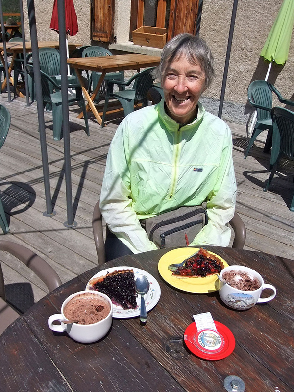
Mercantour – Day 1 The Col de la Bonette features in today’s itinerary and there is often some confusion about its height and status. Also much of our holiday cycling has been about Cols this year. So this Blog post will be a bit different in that it will start with an explanation of some of the arcane law appertaining to collecting Cols. Should you be interested, pay attention: Just as some hill walkers spend years “bagging” Munros in Scotland, there are cyclists who collect Cols. Like so many things to do with cycling the organisation that regulates such activity is French. it is the Ordre des Cols Dur (OCD). The chaps who run it also have OCD tendencies in devising their arcane rules. Mostly it is about the Alps and Pyrenées, but may involve mountains anywhere in the world. 1. There is a minimum height you have to climb to get to the Col. Seems reasonable, you can’t count a hump back bridge in Norfolk. 2. The road must go down from the col in two or more directions. Can just be up and over or there may be a junction at the top with a choice of roads. This means that dead end mountain top finishes are not Cols. No points for climbing Alpe d’Huez. 3. There must be higher land beside the road on at least one side of the road. This rules out summits. So if you climb Mont Ventoux from Bedoin and descend to Malaucene, although you have complied with rules 1 & 2 you get no points. ( if someone built a summit bypass just below the top of Mont Ventoux you would score a Col, but I guess most people would still go to the top!) 4. The minimum climb height rule can make direction of travel important. X and Y are two places of equal height. You climb a long way from X to Col A, then go down just a bit and then climb a long way to Col B before descending to Y. Score = 2 Cols. Same journey from Y to X involves identical metres of up and down, but you only score one Col (Col B) because the height gained on the climb to Col A is not enough. 5. There’s lots more but the only other rule you need to know today is that if you start from X and climb over a Col you must be able to descend and live happily ever after without ever visiting X again. You may do a circular route, or you may climb the Col and turn round and come back again the same way and still score 1 Col, providing you could have carried on to somewhere else had you so wished. Got all that? We will explain about the Col de la Bonette in a minute, but first there is some other information about high level Col collecting you should have: My locally produced guide to Alpine Cols helpfully explains that if you live at sea level (e.g. Lymington) your VO2 MAX will be reduced by about 15% at 2,500m, which is a smart way of saying you’re going to be short of breath even before you do anything energetic or daft like cycling up hill – gee thanks for turning down the oxygen. Getting enough oxygen into your system is all about pacing yourself. The guide we were given to make sure that we were setting ourselves an appropriately steady pace involves two tests. 1. When asked a question you should be able to answer with a whole sentence. Means enough oxygen is getting to muscles with a bit to spare for talking. 2. The answer should make sense (or at least be a bit coherent). Means that there is also a bit of oxygen to spare to keep your brain just about functioning (of course some of us fail this test sitting down at sea level). The other practical demonstration of reducing air pressure, is the crisp bag test. If you fancy taking a salty snack and buy a bag of crisps in Barcelonnette, and pop it in your bumbag, the bad news is that it will have exploded due to reducing air pressure before you get to the top of the Col de la Bonette. This also poses the dilemma of should we reduce the pressure in our tyres as required by airlines shipping bikes in un-pressurised aircraft holds? You will have to work this out for yourself, but as we are now safely back down with no exploded tyres on the trike, we obviously made the right decision. Now what about today’s tandem tricycle excursion – read on: As near perfect weather as it would be possible to have. Blue sky and sunshine blazing down, but cold mountain air keeping the temperature down and no wind to speak of. The goal of the day is to cycle within the Mercantour National Park to the top of the Col de la Bonette (A TdF HR climb, although only occasionally used as part of the TdF route) and then on to a personal road cycling “high point” by cycling to the summit point on the highest paved road in Europe. The road junction at the Col de la Bonette involves the roads from Jausiers and from Nice, together with the two ends of a road that circles around la Cime de la Bonette mountain top. The Col at the Nice and Jausiers roads junction is 2,715m high, which makes it the second highest Col in France being a spit lower than the Col d’Iseran. The road encircling the mountain top climbs to 2,802m ( or as Sheila prefers 9,200ft). It complies with OCD rules 1 to 4, but because it fails rule 5 no Col claim is allowed, just the glory of cycling altitude achievement. Aspects of the scenery are different once again, but ‘awesome’, breathtakingly beautiful and of course big. A twisty turning road as well as sections of clambering up hairpin bends. From quite steep rocky valleys opening onto high Alpine pasture with small tinkling steams created by a sequence of glacier formed hanging valleys. On the way back down Sheila became a bit overcome with some Heidi or Sound of Music moments. Loads of small gentians mixed in with yellow violas and heaps of little white jobs whose name we do not know. Marmot spotting took off in a big way during the middle part of the climb – sitting up and whistling, crossing the road and giving us a wary looking over. Our total marmot spotting tally reached 16, which is another wildlife Col climbing personal best for us. We saw 15 going up and one coming down. I’m sure there were more on the way down. But trying to read the road ahead on a high speed descent and/or just hang on so as not to be bounced off the trike is not conducive to detailed wildlife observation. Climbing higher brought us into grassy moraine hillsides and we continued past the snow line and way on above. The climb itself varied continuously with some parts a relatively benign 6%, but also plenty of 8% and 10% sections and from time to time it was around a corner laid back in the recumbent seat looking at nothing but blue sky and climbing at 15%. On some of these latter parts I would have totally failed both the altitude question and answer tests, but as we were only climbing at about 5kph on these, slowing the pace down really was not an option. Needless to say climbing was punctuated by stops “to admire the view” but also to eat and drink and bring one’s heart rate down to something that would not scare one’s GP. Eventually a long view of what was probably the Col above the snow lined road opened up, but as we have come to know it is always further than it looks. But it does arrive, or rather it stays put and we arrive. At the Col we were faced with a road blocked by snow and sight of a digger or snow plough (we weren’t sure which) working away higher up and further along the road. We pulled across the Col top and stopped just behind the hill with a couple of cars and quite a few motorbikes on the other side out of the slight breeze. It was pleasantly warm in the strong sunshine. Looking up the other leg of the road around the mountain we could also see a snow plough and a large digger at work carving snow and fallen rock debris from the side of the road and dumping it down the mountainside. This end of the road was not completely blocked but no-one was venturing up. The snow plough came down and a few people set off walking. The road look clear as far as we could see, so we thought, “why not”, “let’s see how far we can get”. We climbed away from the Col, pausing when we reached the manoeuvring digger. It looked a huge beast with giant wheels encased in a massive array of snow chains. We crept past and there was no shouting from the driver to say stop and go back. Apart from a very small amount of melting snow the road was OK so we pressed on. Eventually we came to a Route Barrée sign in front of snow completely blocking the road. But, good news, this was 20m beyond the summit. We had reached the line across the road, and the large rock beside the road with a plaque proclaiming 2,802m. Obligatory photos followed. The view of the surrounding mountain chain was truly panoramic with the tops not looking much higher than us. We descended back to the Col very cautiously and shortly afterwards the workmen again dumped more snow from the side of the road closing it again. Oh, I should have mentioned that the 1km climb from the Col to the summit was a 20% gradient. Stoked up on an assortment of biccies and bars and set off down. Descent fast at times, but with stops to take photos and just to look around; and back down in mountain meadows was a little stone and tin roofed hut wedged into the side of the road. There were picnic tables, a super view and it was serving drinks and snacks, which included a delicious courgette tart. Just about perfect end to a perfect cycling day out. Thursday
Blue sky and sunshine, with cloud building late morning into afternoon. Cold but calm mountain air. Excellent decision yesterday to postpone cycling until this morning. This year’s Tour de France route includes, as Stage 14, a day when they come from the Col du Lautaret (been there) through Briançon and then climb the Col d’Izoard (an HC climb to altitude 2,360m) before going on to a mountain top finish at Risoul. The Col d’Izoard will be the highest col climbed by the 2014 TdF. It is 2014 and we are staying in Briançon, so we really cannot turn away the challenge of cycling part of this year’s route and checking out the Col d’Izoard summit for them. No need to get carried away though, we can happily leave out the Stage finish at Risoul. Much of the climb through wooded hairpins, breaking out near to the top into another different (to us) landscape of rather bleak moraine summit slopes with earth pillars described as ‘Casse-deserte’. Sheila looked as calm as ever, but John struggled to get going sweating enough for both of us. Perhaps two non-cycling days has had an effect? Usual stream of motorbikes, cyclists overtaking us and heaps of wild flowers, with the climb interspersed with stops to eat, or have a comfort break, or just to stop. Photos at the top and of various view out. 1km below the Col was an auberge – the Refuge Napoleon – built in 1858. We rapidly free wheeled around a few sharp bends to arrive there. Sat in the sunshine and enjoyed large cups of hot chocolate and really good tart. Could not decide between myrtile and fruits of the forest, so we ordered both and shared half each. Fleeces on, pertex tops on, gloves and mitts on. One turn of the pedals and we were off on the descent. A few stops on the way down just to look at the views and the drop below. Packed up and motored to Barcelonnette ready to begin our exploration of the Mercantour tomorrow. Barcelonnette has a fascinating history. Many residents emigrated in 19th century to Mexico, some returning to build fine villas. Town now has a frontier France and Italy flavour spiced up by Mexican influences. Google ‘Barcelonnette’ for more. PS. Have at last worked out how to do âçcéñts on the iPad, but I am not going back to update all previous posts – John (or José in Barcelonnette) Wednesday
Lots of dithering about and indecision because the weather forecast was not absolutely dire, but also not good and if not wet we would probably at least be in a damp cloud with no views. So decision time. If we get up and go efficiently and early(ish) tomorrow, we could still climb and return from the Col d’Izoard with time to pack and make a car transfer to our booked accommodation for the night in Barcelonnette. OK. Let’s be car based tourists. Sheila proposed an itinerary driving along the valley of the river Durance, enjoying the scenery and with the Serre-Ponçon dam as a destination. The dam was conceived in the early part of the 20th century, to control seasonal flooding by the River Durance, but work only commenced in 1955, with completion in 1961. It is the largest earth dam in Europe and currently the lake formed is the second largest in Europe. The ability (design and construction) to build the dam came following various large earth dams being built in the 1950s in America (including some failures) from which much was learnt. All the earth moving plant was imported from the USA via Marseille and driven (slowly) to the site. At the dam there is an excellent visitor centre – Museoscope – with an hour long programme including models of the valleys flooded with their villages, films about the valley and the villages, moving villagers and building a replacement for one of the villages, contemporary and later film of reminiscence, and an explanation of the design and construction. A very worthwhile visit. Lunch at a cafe above the centre, then a drive around one of the flooded valleys with view point stops en route. We also stopped to go and see the Demoiselles Coiffées: a series of quite dramatic perched rocks formed by erosion of glacial moraine below large erratic deposited rocks. Afternoon tea stop in Guillestre. Sat in the square and drank thé Anglais (yes in a pot and with cold milk) – how very British on holiday in foreign parts. The decision on weather was probably a good one, because lots of low cloud around and scattered rain including a bit of heavy ‘orage’ sweeping across while we were in the car. But we managed to stay dry while out doors and returned to evening sunshine breaking through in Briançon. Used all the gears on the car, with some significant ups and downs, but we were never out of breath once. Perhaps Mary’s Mike has hit on a winning formula after all? Will we be able to summon the legs and inclination to return to the Trike tomorrow after two days off? Tuesday
Non-cycling car transfer day Drove to Briancon via the Frejus tunnel, thereby giving us a short excursion into Italy. Set off to explore the old town, described as artistic and historic with its Vauban fortifications designated as a UNESCO World Heritage site. Obviously not the tourist season. Narrow streets that one would expect to be teeming with visitors were quite empty and most of the boutiques, shops and cafés were closed. Briancon really does not push its historic town. No walking tour, no descriptive plaques on key buildings and the tourist office has leaflets on nearby attractions, white water rafting etc but nothing at all about its own historic town Stopped for a snack lunch just in in time to sit out heavy rain and thunder. When it cleared, the weather remained very cloudy so we retreated in drizzle down the hill and back to our auberge. The auberge had given us an upgrade to a room with a balcony at no extra charge. But as the balcony just looked straight into a building site we did wonder if the upgrade should have been to give people with balconies a quieter room on the other side without a balcony! Clouds and rain remained – felt a bit like the Lake District, just a lot higher. John looked up various things on the internet and did a bit of work correspondence. Sheila went to sleep. Decided not to venture out in the rain again during the evening, so stayed in for dinner. Thought we might have escaped football stuff by going on holiday at this time, but the big screen television in the corner of the auberge lounge was churning out World Cup soccer. By careful selection of our seats we managed to be too far away to know who was playing whom and with a mixed French, Belgium and English clientele (but no obvious Brazilians) we thought it best not to ask who was winning in case it was the ‘wrong question’. Forecast for Wednesday not too good either, will have to check later in the day and in the morning. Monday
A rather restful day, we just climbed the Col du Telegraphe, then came down and idled our way through a picnic lunch and the afternoon. This is ridiculous we have just been to the top of a Cat1 TdF col and I am describing it as a rest. How one’s perspective changes in a week!! But the truth is that the Col du Telegraphe and the Col du Galibier are always climbed together on the TdF, but being tourists we decided to have a night in a hotel in between :-) and from Valloire at the foot of the descent from Galibier to the top of the Col du Telegraphe at 1,566m is no great distance or height gain, although coming down seemed speedier than I expected from the climb up. Weather almost perfect, blue sky sunshine with some clouds and the temperature down to manageable 20s Celsius. A 4 marmot day. Well actually 4 for Sheila and 3 for John who was looking the wrong way admiring the drift of Alpine flowers in a passing meadow. But another first – we have climbed to the top of a TdF Col in the middle ring. Could have changed down at one point, but it was a very short only slightly grippy (well not really even bottom of scale grippy) bit so we pushed through. So to summarise: If you ever find yourself in Valloire with a bicycle, head north for a very pleasant short and steady cycle trip to the Telegraphe or head south for the full-on HC high altitude experience of Galibier. No cycling tomorrow, because we are relocating the car to Briancon for our next challenge. We have decided to go via the valley roads and the Frejus tunnel for some different scenery and a long underground mountain trip. Sunday
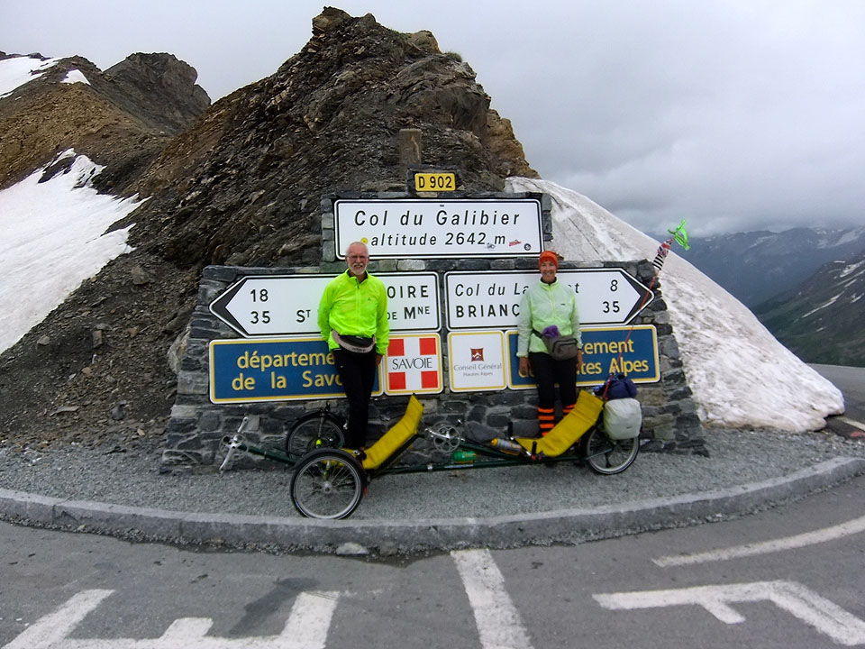
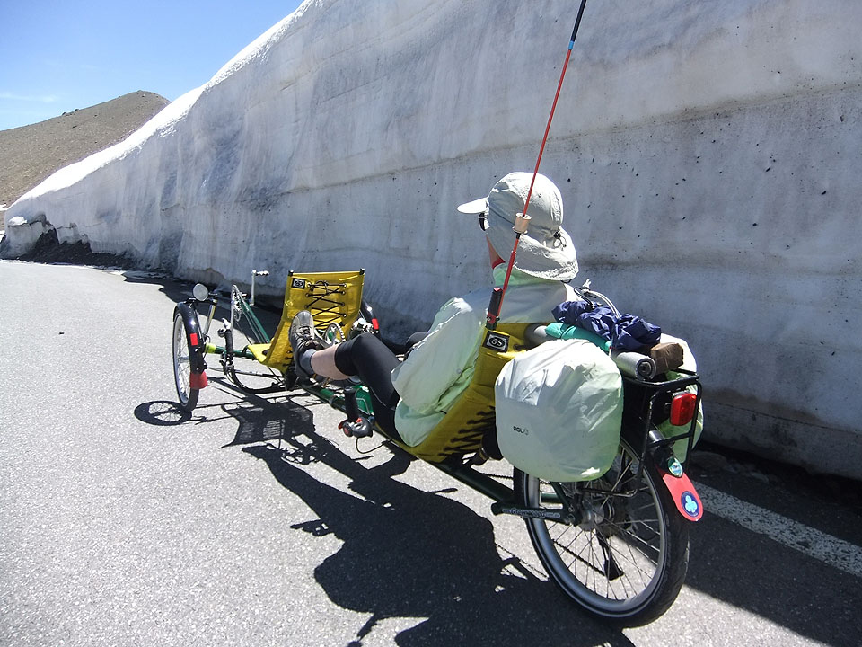
Degrees of indecision about what to do today. Originally we had thought it would be a travel / rest day before tackling the Col du Galibier on Monday, but as we have our car here in Bourg d’Oisans we can decide on how active or inactive to make today. The weather has changed quite dramatically from very hot and sunny to cool and rainy. We studied three weather forecasts and although not totally agreeing their general points were that for today and tomorrow at the Col du Galibier there was a 40% chance of rain, with snow at 2,800m and above (which is less than 200m higher than Galibier). The temperature would be about 1 degree C, but feeling about -5C with wind chill. So, we had a leisurely breakfast and then mooched through the town centre to watch the start of a running race. Their circuit took in 3 villages in the area and included climbing 1,000m on the way. There were competitors from all parts of France. Most were just wearing typical marathon running kit, but several also carried walking poles, so we were not quite sure how steep or rough all the up hilling was going to be for them. It is a long run in from Bourg d’Oisans to Galibier on a fairly main road for much of the way with a collection of tunnels of varying lengths. So after a bit of dithering we decided to drive to the Col du Lauteret, see what the weather was like and then decide whether to put the trike together and tackle Galibier from there. This would make the climb shorter, but still “epic” compared with anything on offer in Britain! We packed all our winter mountain clothing and set off. The Col du Galibier is an HC climb reaching 2,645m, which makes it a true giant and is often the highest mountain col used by the Tour de France. After negotiating the tunnels on the main road we were both quite convinced that they would not be much fun at all on a bicycle. At the car park it was a bit windy, but not rainy and the cloud base was above us (a bit) so we resolved to go. Galibier: It is BIG. Looks big and feels big. Lots more snow close to us beside the road and above and below us than on previous days. Just all felt a lot more “mountain”. Like on some other days tons of motor cycles out – respectable looking tourists and also Rockers not looking like the person you would want your sister to go out with. But all were very friendly with their waves and encouragement. Sheila was going OK, but John struggled and made hard work of the first km (perhaps having underestimated how much Alpe d’Huez had taken out me yesterday?) Sheila asked if I was out of breath and when I finally had enough breath to reply and say ‘no’, she said OK, we go on. After a snack and roadside loo stop, we both got going well and the gradient was “steady” rather than “grippy”. Heard a marmite (oops, marmot) but did not see any. Lots of white mountain narcissus though and Sheila spotted a couple of white pasque flowers. There is a tunnel about 1km before the col. This was closed for 30 years but was re-opened recently for motor vehicles. Cyclists are not allowed through the tunnel and still have to go up and over and this final push to the Col was decidedly grippy, kicking up to 12%. We really were lucky at the top though because the rain held off (apart from small drizzly bits) and the cloud base had lifted above the Col as we were coming. Photos taken, we put on lots of clothes and dropped carefully back down around the tight hairpins to the tunnel and nearby cafe. A welcome hot chocolate stop and John got carried away and bought a T shirt. Sheila resisted (thank goodness) buying a very fetching (she said) yodelling, furry marmite in a felt Tyrolean hat with feather. Outside the cafe is the monument to Henri Desgrange – the man who first organised the Tour de France in 1903 and also the man who inaugurated Audax cycling events. An essential photo stop for cyclists. All clothes on for the descent. Sheila sporting an additional two fleeces, buff, skiing mitts, pertex wind proof and mountain waterproof AND the stripy leg warmers. John in not much less. The windchill dropping down the mountain on a bike at 40 to 50kph is something to respect. Late lunch back at the Col du Lauteret, then motored home to Bourg d’Oisans. A bit of essential shopping before showers included buying a replacement bottle cage for a broken one, some more magic powder (electrolytes) for drinks. And most importantly the back half of the sole of one of John’s cycling shoes had come away and required urgent attention. A friendly bike shop glued it back together – just hope it stays stuck. Saturday
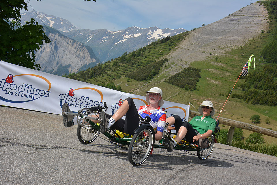
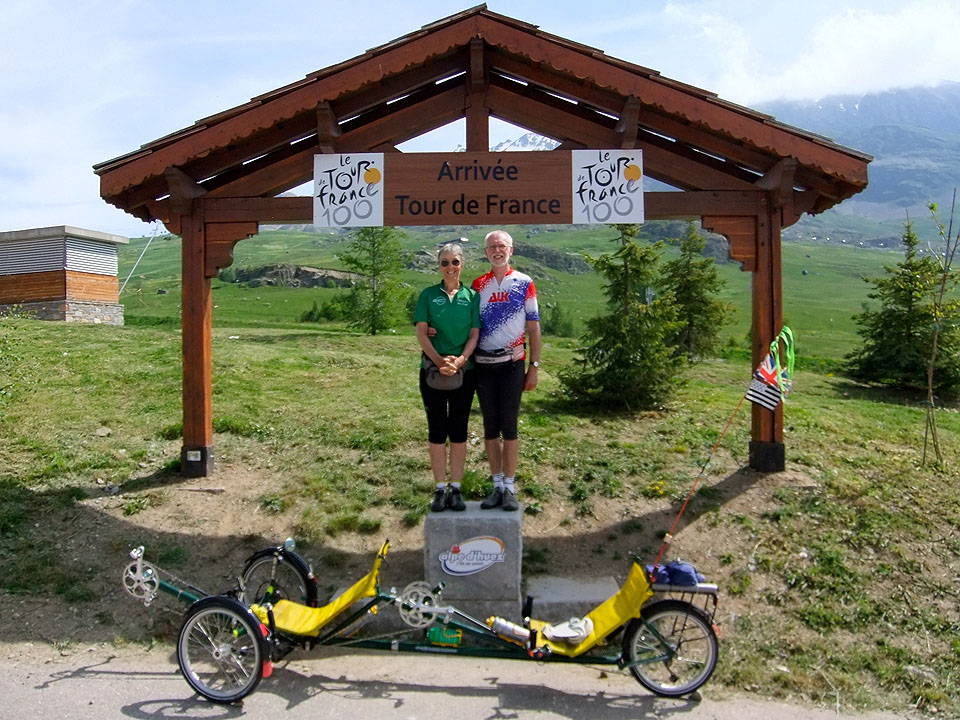
It is a pity that “iconic” has been so misused and over-used in the last couple of years because Alpe d’Huez is the iconic Tour de France mountain stage finish. A TdF HC climb in its own right it has been used in two out of three years in le Tour since it was introduced in the 1960s. You don’t really go anywhere in the normal horizontal sense of travelling. The climb from Borg d’Oisans to Alpe d’Huez is basically a ladder thrown on the mountainside without a lift offered as an alternative to the ‘stairs’. There are 21 virages (hairpin bends) from No. 21 at the bottom to No. 0 at the finish. On each is a board with the names of one, or sometimes two, TdF stage winners on Alpe d’Huez and also the height on this bend counting up to 1,860m. Ascent is 1,100m (Sheila wants to go Imperial at 3,575ft because it sounds better). No gentle start to this one because the hardest part is at the start. Tuesday cyclists who went on our first tour may remember the hill on the Marlborough day that we all walked up (even Determination Mary who went a short way then stalled) – just keep this in mind. Out of Bourg d’Oisans, round a left hand bend and you slam straight into the climb and rattle down through the gears. This toughest part through the first 5 hairpins has two potential problems. If you don’t make it – game over. If you do make it but are rendered legless then it is still a long way to the top and although instead of being ridiculously very steep the remainder is just very steep, it is probably game over before the finish. Our tour leader seemed to be incapable of using the st**p word and so had described the climb as a bit grippy on the first part followed by a grippy section on the next part, then some grippy climbing etc etc, with the only variation being to describe one part as “a bit cheeky”. Anyway we knew all about pacing ourselves and not starting out too fast (joke) and we were going for a personal best. So as we rolled over the start line we checked the calendar. It said Saturday morning, 14th June 2014. We were off. And I ought to mention we had about an hour and a half start on the others. Grippy the first section certainly was, but we were going well and in a forward direction. Coming down the mountain and roaring past us were the sports cars on the Coupe des Alpes. Nearly all waved and encouraged us but we were slightly concerned, when the driver and navigator of one open top machine both raised both hands at once to salute us. Quite a bit of shade, with the mountain between us and the sun on the first half of the climb was welcome. A few brief stops to eat and drink helped us along and Sheila decided a comfort stop was required when we were at the apex of one left hand hairpin. Reaching Alpe d’Huez with its cafés and shops was great, but the bad news was that we had to carry on through still climbing because the TdF finish is a further 2km on up the Alpe, No matter, with the finish ‘in sight’ we were going well and shifted gear to pick up the pace. Finally crossed the line with Sheila, somewhat uncharacteristically, urging John to sprint. We checked the calendar again – Saturday morning 14th June 2014 again. Fantastic. A personal best that could not be bettered. Who wants to get into trivial detail like hours and minutes. But for the record we finished in 2hrs 30mins including stops and we were not caught by any of our group. Usual photos at the finish, including on the TdF stage finish podium which is left at the Alpe d’Huez line. As we had been on a tandem we shared the top step on the podium. Watched some of our team mates come in then drifted back down to the village for a coffee. Going back down was as exciting as ever, but we broke it up with photo stops and brake cooling down stops. Almost felt sorry for the steady stream of cyclists toiling up as we shot past in a blur. Picnic lunch at the bottom then time to say au revoir to our team mates of the past week. All in all a great morning out. About the same time as a regular Tuesday ride and we had fitted in coffee at the half way point. Just not sure that Lymington Tuesday cyclists would approve of a route variation that is an unrelieved steep climb to coffee? PS. thought of buying a T shirt but could not see one that was tasteful enough. Friday
Another HC Col and TdF favourite, this time reaching 2,067m. The plan had been to climb the Col de la Croix de Fer from the St Jean de Maurienne side, but conversations with other cyclists who had come down that way the day before led us to change our minds. The general description corroborated by several people was that there was heavy traffic at the beginning going to a quarry, there were sections of melted tar on the climb, there were sections of loose gravel, there were road works and because the road was kept open in winter to give access to a ski resort, much of the road was pretty well wrecked with holes, ruts and in a generally very bad condition. None of this filled us with enthusiasm. So, the new plan was to relocate our car and climb the Col from the other side. We opted to leave the car at the Barrage de Grand Maison, at the bottom of a lake. This started us off part way up the climb on a lovely smooth road. In driving around to here we had seen four marmots, which got Sheila very excited. The first was just a bum and tail disappearing into its burrow, but the others were in full side view crossing the road. Climbing up from the barrage to the Col turned into a semi rest day. The weather was sunny / cloudy with a lower temperature and a gentle breeze. Cycling without being drowned in sweat felt good. We poodled along slowly, for the first time not just going slow because we could go no faster, but actually (on the not too fierce gradient sections) just because we felt like it. We stopped on the way several times to admire the view and eat snacks, and the trip turned into a marmot spotting day. Our final score was 14, sitting up, running along, or just marmoting. We even managed to crawl along the road edge slowly and photograph one – felt quite wildlife safari. Coffee and then picnic at the Col with usual photos. This time of both the Col sign and of the Croix de Fer, which marked an old pilgrim route. Good run down and a short detour to the top of the Col du Glandon at 1,924m. This was a real cheat because, although the climb up the Col du Glandon from the side valley is really tough, we just diverted from the Col de la Croix de Fer road and climbed all of about 16m!! Still a ‘tick’ and there was a lovely large bike sculpture that provided a group photo backdrop. Ran into a vast hoard of sheep all over the road and up the hillside on the way home. 21st century transhumance is very much a motorised affair with large quadruple decker vehicles stopped in the middle if nowhere up a mountain disgorging vast quantities if sheep or cattle. Overnight stay tonight in a very comfy chalet stuck up a hillside (as they are) with super views. Thursday
Col de la Madeleine – one of the Tour de France giants and often included. Usually in some crippling stage with La Madeleine and one or two other massive HC climbs also thrown in. But for the likes of us a hotel bed between this and the next big climb seems like a very good idea. This is our first TdF HC Col and for the first time we are just making it to 2,000m. Blue sky and hot sunshine again. Today’s picnic lunch was planned to be at the Col, so we had everything ready and grabbed an early breakfast so as to set off well before the others with a couple of hours start. Otherwise there was a risk that we would arrive after lunch was over. In the event as well as having extra time lunch was a leisurely affair with lots of lying around on the grass. The climb gradient varied through its length which was good because it gave some relief from a constant push. In fact for a bit there was a flat and slight downhill and in another part a km of 3% felt like flat in comparison with what had gone before. Needless to say there were some other kms that were full on where it took an eternity for the next km marker to arrive; and if I had been wearing a heart rate monitor it would have been well in the red zone (or whatever such monitors do) We had previously bumped into the “Fireflies” team on other cols on other days. This is an organised English charity ride across the Alps for tough cyclists. Needless to say they were intrigued by our machine. Luckily for us we met up with them on this climb just before their support van parked on the roadside, which was a life saver, because we were right out of water and they very kindly filled our bottles as well as those of their own team. We stopped at the 1km to go marker to photograph the trike against the snow and Sheila scooped some up to cool down but resisted putting it down the neck of her jersey fearing the shock might be too great. The final km gradient eased off to 5%, which was very kind and you know you are on one the “must do” mountain climbs when there is an official photographer on the last bend before the summit. We took our own photos at the Col and had a picnic lunch at the top. The official Col sign had been removed, but the cafe at the top had enterprisingly had their own made and fixed to the cafe balcony. The Fireflies also lined up for a group photo. The descent was fast and exhilarating. Looking down the steepness of some of the drops in the road while hanging on to the brakes we found it hard to believe we had actually cycled up quite so unrelentingly steep a climb. On the way down we paused a couple of times to admire the view and allow the brakes to cool down. Although hard braking and letting it run alternately avoids burning the rotors (with the disastrous effect of almost total braking loss). The hydraulic brake fluid heats up and expands requiring adjustment of the reservoirs by turning the knurled caps beside the brake levers as you go down. Remembering at the same time to pay attention to the road and the next fast appearing hairpin bend or similar hazard. At one point the local authority had thoughtfully provided a bench perched on the side of the road looking straight down the valley. We reclined here and had a short relax. Hotel in St Jean Maurienne for the night. By 9pm with a breeze blowing the temperature at last reached a comfortable level for sitting outdoors for dinner. Hard to believe the snow is still up there on the mountainside. Wednesday
The itinerary for today included the Col Les Saisies, Cormet de Roselend (Cat 1) and the option of La Plagne. The road to Les Saises was in a terrible condition and would have been a nightmare to trike on so we gave it a miss. The final run down the valley to the hotel for the night was on very busy main roads and again would not have been any fun on a recumbent. And, hot and sunny again with valley temperatures in the rising 30s. So we decided that notwithstanding the fact that it was Wednesday we would settle for a “Tuesday Cycling” style of morning. Started cycling at 10.00am, cycled for about two and a half hours, covered a bit over 30km and then had a roadside picnic lunch instead of a coffee stop. Only difference was that on the way we climbed Cormet de Roselend, a TdF Cat 1 climb taking us up to 1967m at the Col beside snow clad mountain sides. Very scenic in all senses of the word. On the way down we had some rather technical sweeping bends and tight hairpins including Johan Bruyneel corner, which I am pleased to say we successfully negotiated (if you don’t know what this is just Google Johan Bruyneel) Thunder storm now (9:30pm) rumbling around. A good downpour to clear the air would be welcome. Tuesday
The organised Skedaddle itinerary for today was to “to give you the experience of a multi-cols day in a TdF mountain stage”, taking in Colombiere (Cat 1), Aravis (Cat 2) and Les Saisies (Cat 1). The last of these was optional, but even without it there was a fierce third climb to the hotel. Not even a consideration on the Greenspeed trike. Not only would we be physically done in we would be nowhere near the finish in daylight. Colombiere would be enough for us thank you very much. So we took the car to La Reposoir, climbed Colombiere, then descended back again to collect the car and drive to Aravis to meet the others for lunch and then drive on to the hotel. We were really glad we had not done the third climb, it had a wickedly steep start (1st gear in the car) giving out to melted tar and loose gravel, then a section of “trous en formation” where the road was broken up and would be really bad to cycle over on the trike, and finally a stretch where the road had been totally ripped out prior to being relaid. Back to Colombiere: We had been warned that the final 3km were 13%. No worse than the climb to Hardy’s monument on the Coastlet, but a heck of a lot longer. So we took it very steady with pauses and drinks climbing through trees until breaking out above the tree line into rocky terrain. We had also saved our ‘secret weapon’ hub gear as a final low gear, but were very pleasantly surprised to find in fact that the final 3km was at an average of 10% with some 13% sections, but not continuously 13%. Of course if we had not been expecting worse this would have seemed super tough in itself!! Final bottom gear saved for another day. As always, loads of sunshine and fantastic mountain scenery, including from Aravis a stunning view of the Mont Blanc massif including Aiguille du Midi and Mont Blanc summit itself coming in and out of cloud cover at its top. Yesterday drove to Morillon where we are staying for two nights.
Spectacular scenery as we got closer to the high Alps, with lots of snow still on the tops (and some of the middles) BLIMEY, they’re big. Met the rest of the group. All much too young, much too fit, much too eager and they can’t imagine what a couple of pensioners are doing on a bike, ’cause even their parents who are obviously much too sensible for such things aren’t anywhere near collecting their pensions. Monday (this one is for Mary, who probably does this bike ride each Tuesday when she holidays here) Climbed to Avoriaz via Morzine. Avoriaz is a ski station that has been used at various times in the past as a TdF mountain stage finish. 1800m high and featuring quite a lot of 8% climbing. Climbed for 2 hours 14 minutes excluding roadside breather stops. Like some other French climbs there were marker posts every km telling you how far to the top and the average gradient for the next km. Not sure if they are all that encouraging because when you have passed one the next seems a long time and too many hairpin bends before it comes into view. We set off as early as we could and paused on the climb when we got the opportunity of a bit of shade because it was ridiculously hot again reaching 38 degrees in the valley. At the top it was as desolate as ski stations always are in the summer, but the views were great and we could actually look down at some snow. Drinks and snacks at the top and a picnic lunch back in Les Gets after a speedy downhill drop. The others said that when they looked down on us we appeared to be a 2-man (probably ought to be person) bobsleigh team, and we should take it up in the veterans category. We are doing a bit of re-planning of car moving rather than doing a straight 7 day moving on tour, so as to stick to the organised schedule for overnight stops, but give us some flexibility of shortening some days. Otherwise we have no get out options. If any of the others has an off day or part day they can hop in the van / minibus for a bit and put their bike on top, but with our trike this is not an option. |
AuthorMostly diary notes about out tandem tours and some day rides Archives
June 2014
Categories |
 RSS Feed
